The multibillion-pound infrastructure set for the East of England
The government and private companies have said they plan to spend billions of pounds on huge projects across the East of England.
They include bigger airports, a new railway line and theme park, as well as developments that will keep the lights on and taps running.
But where are some of the biggest and what stage have they reached?
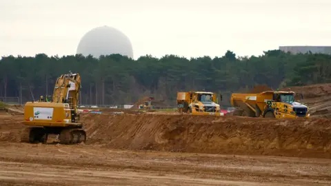
Sizewell C

 Sizewell C
A 3.2GW nuclear power plant is planned to be built on the Suffolk coast next to Sizewell B, which began generating in 1995.
According to energy company EDF, Sizewell C will produce 7% of the UK's electricity - enough for six million homes - for 60 years.
Neither EDF nor the government have said how much the plant is likely to cost overall, but the chancellor confirmed £14.2bn of investment into the plant in the 2025 spending review. That brought total taxpayer investment into the project to £17.8bn.
EDF said 10,000 jobs - including 1,500 apprenticeships - would be created during construction. Once operational, it will employ 900 people.
But local communities have battled the plans.
The plant should start providing power in the early 2030s.
 Martin Giles/BBC
East West Rail
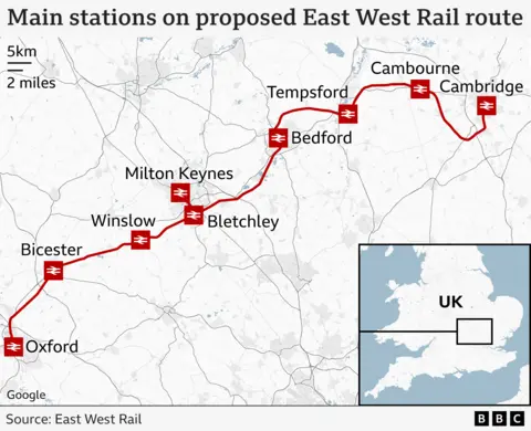
The £6bn East West Rail (EWR) project is being developed in three sections.
Trains should start running between Oxford and Milton Keynes, via Bletchley, by the end of 2025.
Work is already under way to upgrade the line between Bletchley and Bedford, which will be the second section.
Finally, a wholly new track is being planned between Bedford and Cambridge, which could see new stations at Tempsford and Cambourne.
EWR said it could take one hour and 35 minutes to travel on its route from Oxford to Cambridge, about an hour less than the current fastest service.
The chancellor committed £2.5bn to the project in the 2025 spending review and said she did so "to back Milton Keynes' leading tech sector". The project is also expected to unlock land for thousands of new homes.
A statutory consultation is being planned for 2026 and EWR could apply to the government for a development consent order - giving overall planning permission - in 2027.
Critics of the scheme have said it would damage the countryside between Bedford and Cambridge. Houses in Bedford could also be knocked down to make way for new tracks.
Trains could be running along the whole route by the mid-2030s.
Fens Reservoir
 Anglian Water
This joint £2.2bn project between Anglian Water and Cambridge Water will see a 21 sq-mile (55 sq-km) lake built north of Chatteris in Cambridgeshire.
It could be suppling 87 million litres (19 million gallons) of water a day for up to 250,000 homes by 2036.
Water will be pumped from the River Nene, Great Ouse and the Ouse Washes, or a combination of these.
The water companies said they faced "growing challenges" to water supplies. The East region, they added, was "low-lying, one of the driest in the UK and especially vulnerable to a changing climate".
The Environment Agency has previously objected to large developments near Cambridge because of concerns over a shortage of water. The government set up a Water Scarcity Group to try to tackle the issue and allow the city to continue growing.
The two firms are also working together on transferring water from Grafham Water, a reservoir that was completed in 1965. Anglian is building a 205-mile (330-km) pipeline to transfer water from Humberside to Essex.
Both companies said they were supporting customers to use less water and installing smart meters to help identify leaks.
Customers' bills will rise to help pay for new infrastructure.
Solar
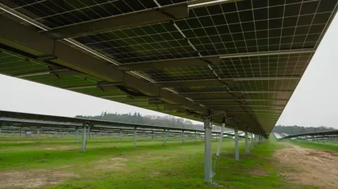 Martin Giles/BBC
Large-scale solar farms with a combined generating capacity of more than 4GW are being planned across the East of England, Northamptonshire and Buckinghamshire.
Longfield Solar, a 400MW development near Chelmsford, was given planning permission in June 2023.
Sunnica, a 500MW facility occupying 2,400 acres (970 hectares) straddling the Suffolk-Cambridgeshire border near the village of Burwell, was approved last July 2024.
The largest solar project on the Planning Inspectorate's list of Nationally Significant Infrastructure in the East, is High Grove Solar in Norfolk, which would have a capacity of 720MW and includes 4,000 acres (1,600 hectares).
Some proposals have prompted local protests.
Airport expansion
 Luton Rising
Both Luton and Stansted airports want to grow.
In April, the government approved plans for the former to build a second terminal building and apron, and to almost double passenger numbers to 32 million a year by 2043.
Stansted announced in June that it was applying to increase its maximum number of annual passengers to 51 million by 2040.
Last October the Essex airport's owner announced a £1.1bn expansion plan that would see its terminal building improved and expanded by a third.
Work was expected to start in 2025 and could last between two and three years.
Luton said its project would create up to 11,000 new jobs, while Stansted's would create more than 5,000.
Campaigners against Luton's plans started legal action to try to stop them, while Hertfordshire County Council called for a delay to Stansted's project.
Electricity grid upgrade
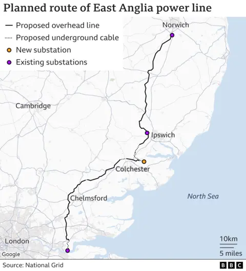
There are several projects to upgrade the electricity grid in the East.
National Grid is planning to "reinforce the high voltage power network" in the region with a new connection between substations in Norwich, Bramford in Suffolk, and Tilbury in Essex.
Some of the 114-mile (184km) route will be underground, but most will see new pylons carrying the wires, which would be a disaster for the countryside, according to some local communities.
The project is designed to help bring power generated by off-shore windfarms ashore.
National Grid said it expected 15,000MW of new generation over the next decade in the region, but that "in its current state, the high voltage electricity network in East Anglia doesn't have sufficient capacity to accommodate this new generation".
It is also planning a new connection between Bramford, and Twinstead Tee in Essex. That will see 11 miles (18km) of new overhead wires and about seven miles (11km) of underground cables.
Sea Link, an undersea cable connecting Suffolk and Kent, is also planned, as well as LionLink, which would connect the UK and the Netherlands, via a Dutch offshore wind farm.
Universal theme park
 Universal Destinations & Experiences/Comcast
In April, the government confirmed that Universal Studios owner Comcast planned to transform the former Kempston Hardwick brickworks south of Bedford into a 476-acre (193 hectares) theme park.
The plans would create 20,000 jobs during construction and another 8,000 when the park opens.
It is thought the park could attract 8.5 million visitors in its first year and boost the economy by £50bn by 2055.
According to Universal's plans, there will be a 500-room hotel and retail complex on the site.
Two train stations could serve the theme park - one on the Thameslink line at Wixams and another on the Marston Vale Line, which is becoming East West Rail.
A dedicated junction on the A421 could also be built.

Lower Thames Crossing
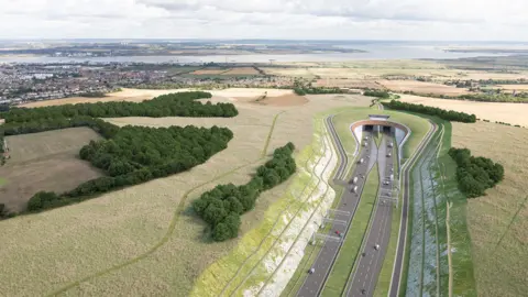 National Highways
The new Lower Thames Crossing will see the UK's longest road tunnels built under the river, providing another road connection between Essex and Kent.
The Department for Transport said a new crossing was a "priority infrastructure project" in 2011, but the scheme was only approved by the government in March.
The £9bn plan will connect the A2 and M2 in Kent to the A13 in Thurrock and junction 29 of the M25.
It will be 14.3 miles (23km) long, with 2.6 miles (4.2km) of that underground. National Highways said it would "almost double road capacity over the river east of London to reduce congestion".
People living nearby have described the proposals as like a "noose around our neck".
A428 dual carriageway
 National Highways
Building a new 10-mile (16km) dual carriageway section of the A428 from the Black Cat roundabout on the A1 to Caxton Gibbet in Cambridgeshire will save drivers up to 10 minutes each way.
It was the only section of single carriageway on the road between Milton Keynes and Cambridge.
About 25,300 vehicles use the stretch every day but that is expected to rise to 32,900 by 2040 as the area gets more homes and businesses.
National Highways started building the £1bn project in December 2023, and it is expected to open in spring 2027.
It is the organisation's biggest project currently being built.
Grade II-listed cottages were dismantled to make way for the new link.
 National Highways
Follow Suffolk news on BBC Sounds, Facebook, Instagram and X.